ArcGIS.Server.9.2.DotNet实现EditorTask功能扩展
来源:互联网 发布:仪器比对 数据分析 编辑:程序博客网 时间:2024/04/28 15:41
目的:
1.arcgis server9.2 ADF实现EditorTask功能扩展。在EditorTask控件上添加地理元素框选裁剪和选中元素数量统计功能。
准备工作:
1.参考DeveloperKit/SamplesNET/Server/Web_Applications目录下的Common_CustomEditorTaskCSharp.zip。
2.本例是在ArcGIS.Server.9.2.DotNet实现在线编辑EditorTask使用(自带例子 十、二) 基础上做的。
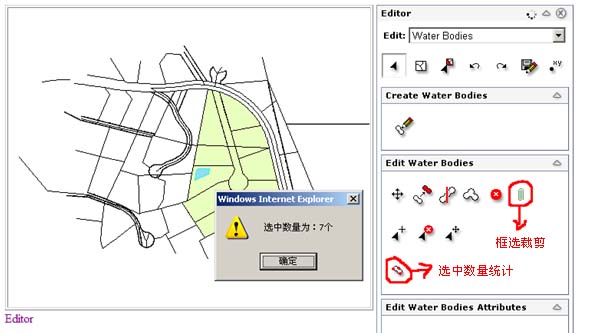
完成后的效果图:
开始:
1.在上一篇中已经实现了EditorTask控件的使用,已经编辑属性的过滤控制等功能,本篇在上一篇的基础上实现 EditorTask功能扩展,在Editor面板上添加一个框选裁剪和选中数量统计功能两个自定义功能。
2.首先在Page_Init页面事件中添加EditorTask1的ToolsCreated事件,代码如下:
6.这里例子中还有一个自定义 TooledEditorPanel的实现了,觉得不是太有用了这里就不详细讲了贴一下代码和说明。
1.arcgis server9.2 ADF实现EditorTask功能扩展。在EditorTask控件上添加地理元素框选裁剪和选中元素数量统计功能。
准备工作:
1.参考DeveloperKit/SamplesNET/Server/Web_Applications目录下的Common_CustomEditorTaskCSharp.zip。
2.本例是在ArcGIS.Server.9.2.DotNet实现在线编辑EditorTask使用(自带例子 十、二) 基础上做的。
完成后的效果图:
开始:
1.在上一篇中已经实现了EditorTask控件的使用,已经编辑属性的过滤控制等功能,本篇在上一篇的基础上实现 EditorTask功能扩展,在Editor面板上添加一个框选裁剪和选中数量统计功能两个自定义功能。
2.首先在Page_Init页面事件中添加EditorTask1的ToolsCreated事件,代码如下:
1 protected void Page_Init(object sender, EventArgs e)
2 {
{
3 //ToolsCreated事件
4 EditorTask1.ToolsCreated += new ESRI.ArcGIS.ADF.ArcGISServer.Editor.Tools.ToolsCreatedEventHandler(EditorTask1_ToolsCreated);
5 
6 }
}
3.在EditorTask1_ToolsCreated方法中实现框选裁剪和数量统计2个功能按钮的添加,具体代码和说明如下:protected void Page_Init(object sender, EventArgs e)2
{
3
//ToolsCreated事件4
EditorTask1.ToolsCreated += new ESRI.ArcGIS.ADF.ArcGISServer.Editor.Tools.ToolsCreatedEventHandler(EditorTask1_ToolsCreated);5
6
} 1void EditorTask1_ToolsCreated(object sender, ESRI.ArcGIS.ADF.ArcGISServer.Editor.Tools.ToolsCreatedEventArgs e)
2 {
3 //编辑panel
4 if (e.Parent == EditorTask1.Editor.ExistingFeatureEditor)
5 {
{
6 //编辑panel包含两个toolbars: GeometryToolbar1和GeometryToolbar2
7 foreach (ESRI.ArcGIS.ADF.ArcGISServer.Editor.Tools.EditorToolbar editorToolbar in e.Toolbars)
8 {
9 string ToolbarID=editorToolbar.ID;
10 if (ToolbarID == "GeometryToolbar1")
11 {
12 //name,mapID,useSnapping,geometryType,minSelectedFeatures
13 //EditorTool的名称,ID,是否扑捉,元素类型,最小选择数
14 ESRI.ArcGIS.ADF.ArcGISServer.Editor.Tools.EditorTool clip =new ESRI.ArcGIS.ADF.ArcGISServer.Editor.Tools.EditorTool("Clip",((ESRI.ArcGIS.ADF.ArcGISServer.Editor.EditExistingFeaturePanel)e.Parent).ParentEditor.MapID, false,ESRI.ArcGIS.ADF.ArcGISServer.Editor.Tools.ToolGeometry.Line | ESRI.ArcGIS.ADF.ArcGISServer.Editor.Tools.ToolGeometry.Polygon, 1);
15 //EditorTool的客户端Action,设置设置成矩形操作
16 clip.ClientAction = ESRI.ArcGIS.ADF.Web.UI.WebControls.Constants.HTML_DRAG_RECTANGLE;
17 //设置EditorTool的图片和tip
18 clip.DefaultImage = "~/images/clip.png";
19 clip.SelectedImage = "~/images/clip_ON.png";
20 clip.HoverImage = "~/images/clip_OVER.png";
21 clip.ToolTip = "Clip feature(s)";
22
23 //设置EditorTool的功能类
24 clip.ServerActionAssembly = "CustomEditorTask";
25 clip.ServerActionClass = "CustomEditorTask.ClipFeatures";
26 //把这个EditorTool添加到Toolbar上
27 editorToolbar.ToolbarItems.Add(clip);
28 //设置宽
29 editorToolbar.Width = new Unit(editorToolbar.Width.Value + 35, UnitType.Pixel);
30 }
}
31 }
32
33 //新建EditorToolbar
34 ESRI.ArcGIS.ADF.ArcGISServer.Editor.Tools.EditorToolbar newEditorToolbar =new ESRI.ArcGIS.ADF.ArcGISServer.Editor.Tools.EditorToolbar();
35 //只显示图标
36 newEditorToolbar.ToolbarStyle = ESRI.ArcGIS.ADF.Web.UI.WebControls.ToolbarStyle.ImageOnly;
37 //id
38 newEditorToolbar.ID = "MyCustomToolbar";
39 //
40 newEditorToolbar.BuddyControlType = ESRI.ArcGIS.ADF.Web.UI.WebControls.BuddyControlType.Map;
41 //设置EditorToolbar的Map控件
42 newEditorToolbar.BuddyControls.Add(new ESRI.ArcGIS.ADF.Web.UI.WebControls.BuddyControl(((ESRI.ArcGIS.ADF.ArcGISServer.Editor.EditExistingFeaturePanel)e.Parent).ParentEditor.MapID));
43
44 //新建EditorCommand
45 ESRI.ArcGIS.ADF.ArcGISServer.Editor.Tools.EditorCommand vertCount =new ESRI.ArcGIS.ADF.ArcGISServer.Editor.Tools.EditorCommand("VerticeCount", ESRI.ArcGIS.ADF.ArcGISServer.Editor.Tools.ToolGeometry.All, 1);
46 //设置EditorCommand的图片和tip
47 vertCount.DefaultImage = "~/images/verticecount.png";
48 vertCount.SelectedImage = "~/images/verticecount_ON.png";
49 vertCount.HoverImage = "~/images/verticecount_OVER.png";
50 vertCount.ToolTip = "Count the number of vertices in the selected feature";
51 //设置EditorCommand的功能类
52 vertCount.ServerActionAssembly = "CustomEditorTask";
53 vertCount.ServerActionClass = "CustomEditorTask.VerticeCount";
54
55 //把新建EditorCommand添加到EditorToolbar
56 newEditorToolbar.ToolbarItems.Add(vertCount);
57 newEditorToolbar.Width = new Unit(newEditorToolbar.ToolbarItems.Count * 35, UnitType.Pixel);
58
59 //把新建的EditorToolbar添加到EditorTask1
60 e.Toolbars.Add(newEditorToolbar);
61 }
4.上面把2个功能按钮添加到Editor面板上后还需要编写实现具体功能的代码,就上面代码中clip.ServerActionClass = "CustomEditorTask.ClipFeatures";和vertCount.ServerActionClass = "CustomEditorTask.VerticeCount";的ClipFeatures类和VerticeCount类,新建CustomEditorTools.cs文件,然后添加如下代码:void EditorTask1_ToolsCreated(object sender, ESRI.ArcGIS.ADF.ArcGISServer.Editor.Tools.ToolsCreatedEventArgs e)2
{3
//编辑panel4
if (e.Parent == EditorTask1.Editor.ExistingFeatureEditor)5
{
6
//编辑panel包含两个toolbars: GeometryToolbar1和GeometryToolbar27
foreach (ESRI.ArcGIS.ADF.ArcGISServer.Editor.Tools.EditorToolbar editorToolbar in e.Toolbars)8
{9
string ToolbarID=editorToolbar.ID;10
if (ToolbarID == "GeometryToolbar1")11
{12
//name,mapID,useSnapping,geometryType,minSelectedFeatures13
//EditorTool的名称,ID,是否扑捉,元素类型,最小选择数14
ESRI.ArcGIS.ADF.ArcGISServer.Editor.Tools.EditorTool clip =new ESRI.ArcGIS.ADF.ArcGISServer.Editor.Tools.EditorTool("Clip",((ESRI.ArcGIS.ADF.ArcGISServer.Editor.EditExistingFeaturePanel)e.Parent).ParentEditor.MapID, false,ESRI.ArcGIS.ADF.ArcGISServer.Editor.Tools.ToolGeometry.Line | ESRI.ArcGIS.ADF.ArcGISServer.Editor.Tools.ToolGeometry.Polygon, 1);15
//EditorTool的客户端Action,设置设置成矩形操作16
clip.ClientAction = ESRI.ArcGIS.ADF.Web.UI.WebControls.Constants.HTML_DRAG_RECTANGLE;17
//设置EditorTool的图片和tip18
clip.DefaultImage = "~/images/clip.png";19
clip.SelectedImage = "~/images/clip_ON.png";20
clip.HoverImage = "~/images/clip_OVER.png";21
clip.ToolTip = "Clip feature(s)";22
23
//设置EditorTool的功能类24
clip.ServerActionAssembly = "CustomEditorTask";25
clip.ServerActionClass = "CustomEditorTask.ClipFeatures";26
//把这个EditorTool添加到Toolbar上27
editorToolbar.ToolbarItems.Add(clip);28
//设置宽29
editorToolbar.Width = new Unit(editorToolbar.Width.Value + 35, UnitType.Pixel);30
}31
}32
33
//新建EditorToolbar34
ESRI.ArcGIS.ADF.ArcGISServer.Editor.Tools.EditorToolbar newEditorToolbar =new ESRI.ArcGIS.ADF.ArcGISServer.Editor.Tools.EditorToolbar();35
//只显示图标36
newEditorToolbar.ToolbarStyle = ESRI.ArcGIS.ADF.Web.UI.WebControls.ToolbarStyle.ImageOnly;37
//id38
newEditorToolbar.ID = "MyCustomToolbar";39
//40
newEditorToolbar.BuddyControlType = ESRI.ArcGIS.ADF.Web.UI.WebControls.BuddyControlType.Map;41
//设置EditorToolbar的Map控件42
newEditorToolbar.BuddyControls.Add(new ESRI.ArcGIS.ADF.Web.UI.WebControls.BuddyControl(((ESRI.ArcGIS.ADF.ArcGISServer.Editor.EditExistingFeaturePanel)e.Parent).ParentEditor.MapID));43
44
//新建EditorCommand45
ESRI.ArcGIS.ADF.ArcGISServer.Editor.Tools.EditorCommand vertCount =new ESRI.ArcGIS.ADF.ArcGISServer.Editor.Tools.EditorCommand("VerticeCount", ESRI.ArcGIS.ADF.ArcGISServer.Editor.Tools.ToolGeometry.All, 1);46
//设置EditorCommand的图片和tip47
vertCount.DefaultImage = "~/images/verticecount.png";48
vertCount.SelectedImage = "~/images/verticecount_ON.png";49
vertCount.HoverImage = "~/images/verticecount_OVER.png";50
vertCount.ToolTip = "Count the number of vertices in the selected feature";51
//设置EditorCommand的功能类52
vertCount.ServerActionAssembly = "CustomEditorTask";53
vertCount.ServerActionClass = "CustomEditorTask.VerticeCount";54
55
//把新建EditorCommand添加到EditorToolbar56
newEditorToolbar.ToolbarItems.Add(vertCount);57
newEditorToolbar.Width = new Unit(newEditorToolbar.ToolbarItems.Count * 35, UnitType.Pixel);58
59
//把新建的EditorToolbar添加到EditorTask160
e.Toolbars.Add(newEditorToolbar);61
} 1namespace CustomEditorTask
2{
3 class ClipFeatures : EditorServerToolAction
4 {
5 private List<int> features = new List<int>();
6
7 public List<int> Features
8 {
9 get { return features; }
10 }
11
12 protected override bool Init(Editor editor)
13 {
14 features.Clear();
15 return base.Init(editor);
16 }
17
18 protected override void EditorServerAction()
19 {
20 //区域
21 IEnvelope env = Geometry as IEnvelope;
22 //map描述
23 MapDescription mapDesc = Editor.MapFunctionality.MapDescription;
24 //选中的Feature数量
25 int[] fidSet = LayerDescription.SelectionFeatures;
26 if (fidSet != null && fidSet.Length > 0)
27 {
28 //geometry拓扑逻辑操作
29 ITopologicalOperator3 topo3 = null;
30 IFeature feature = null;
31 try
32 {
33 //开始编辑
34 StartEditOperation();
35 //IFeatureCursor提供枚举features集合的成员方法,游标
36 IFeatureCursor cursor = FeatureLayer.FeatureClass.GetFeatures(fidSet, false);
37 //获取下一个features
38 feature = cursor.NextFeature();
39 //进行循环
40 while (feature != null)
41 {
42 topo3 = (ITopologicalOperator3)feature.ShapeCopy;
43 topo3.Clip(env);
44 IGeometry geometry = (IGeometry)topo3;
45 if (!geometry.IsEmpty)
46 {
47 feature.Shape = geometry;
48 //存储Feature,存储row
49 feature.Store();
50
51 features.Add(feature.OID);
52 }
53 feature = cursor.NextFeature();
54 }
55 //停止编辑
56 StopEditOperation();
57 }
58 catch (Exception e)
59 {
60 //终止编辑操作
61 AbortEditOperation(e);
62 }
63 if (features.Count > 0)
64 {
65 // Refresh the Editor, Map, vertices, etc. with the new selection set
66 Refresh(features, true);
67 }
68 }
69 }
70 }
71
72 class VerticeCount : EditorServerCommandAction
73 {
74 protected override void EditorServerAction()
75 {
76 ESRI.ArcGIS.ADF.ArcGISServer.MapDescription mapDesc = Editor.MapFunctionality.MapDescription;
77 int[] fidSet = LayerDescription.SelectionFeatures;
78 if (fidSet != null && fidSet.Length > 0)
79 {
80 IFeature feature = null;
81
82 int pointCount = 0;
83 //IFeatureCursor提供枚举features集合的成员方法,游标
84 IFeatureCursor cursor = FeatureLayer.FeatureClass.GetFeatures(fidSet, false);
85 feature = cursor.NextFeature();
86 while (feature != null)
87 {
88 //如果是点类型
89 if (feature.Shape is IPoint)
90 {
91 pointCount += 1;
92 }
93 else//非点类型
94 {
95 IPointCollection pointCollection = (IPointCollection)feature.Shape;
96 pointCount += pointCollection.PointCount;
97 }
98 feature = cursor.NextFeature();
99 }
100 string status = string.Format("alert( '选中数量为:{0}个');", pointCount);
101 ESRI.ArcGIS.ADF.Web.UI.WebControls.CallbackResult jsStatusCallbackResult =new ESRI.ArcGIS.ADF.Web.UI.WebControls.CallbackResult(null, null, "javascript", status);
102 this.ToolbarItemInfo.Toolbar.CallbackResults.Add(jsStatusCallbackResult);
103 }
104 }
105 }
106
107 public class CustomEditorTools
108 {
109
110 }
111}
112
5.这样就完成了2个自定义功能的开发,测试运行。namespace CustomEditorTask2
{3
class ClipFeatures : EditorServerToolAction4
{5
private List<int> features = new List<int>();6
7
public List<int> Features8
{9
get { return features; }10
}11
12
protected override bool Init(Editor editor)13
{14
features.Clear();15
return base.Init(editor);16
}17
18
protected override void EditorServerAction()19
{20
//区域21
IEnvelope env = Geometry as IEnvelope;22
//map描述23
MapDescription mapDesc = Editor.MapFunctionality.MapDescription;24
//选中的Feature数量25
int[] fidSet = LayerDescription.SelectionFeatures;26
if (fidSet != null && fidSet.Length > 0)27
{28
//geometry拓扑逻辑操作29
ITopologicalOperator3 topo3 = null;30
IFeature feature = null;31
try32
{33
//开始编辑34
StartEditOperation();35
//IFeatureCursor提供枚举features集合的成员方法,游标36
IFeatureCursor cursor = FeatureLayer.FeatureClass.GetFeatures(fidSet, false);37
//获取下一个features38
feature = cursor.NextFeature();39
//进行循环40
while (feature != null)41
{42
topo3 = (ITopologicalOperator3)feature.ShapeCopy;43
topo3.Clip(env);44
IGeometry geometry = (IGeometry)topo3;45
if (!geometry.IsEmpty)46
{47
feature.Shape = geometry;48
//存储Feature,存储row49
feature.Store();50
51
features.Add(feature.OID);52
}53
feature = cursor.NextFeature();54
}55
//停止编辑56
StopEditOperation();57
}58
catch (Exception e)59
{60
//终止编辑操作61
AbortEditOperation(e);62
}63
if (features.Count > 0)64
{65
// Refresh the Editor, Map, vertices, etc. with the new selection set66
Refresh(features, true);67
}68
}69
}70
}71
72
class VerticeCount : EditorServerCommandAction73
{74
protected override void EditorServerAction()75
{76
ESRI.ArcGIS.ADF.ArcGISServer.MapDescription mapDesc = Editor.MapFunctionality.MapDescription;77
int[] fidSet = LayerDescription.SelectionFeatures;78
if (fidSet != null && fidSet.Length > 0)79
{80
IFeature feature = null;81
82
int pointCount = 0;83
//IFeatureCursor提供枚举features集合的成员方法,游标84
IFeatureCursor cursor = FeatureLayer.FeatureClass.GetFeatures(fidSet, false);85
feature = cursor.NextFeature();86
while (feature != null)87
{88
//如果是点类型89
if (feature.Shape is IPoint)90
{91
pointCount += 1;92
}93
else//非点类型94
{95
IPointCollection pointCollection = (IPointCollection)feature.Shape;96
pointCount += pointCollection.PointCount;97
}98
feature = cursor.NextFeature();99
}100
string status = string.Format("alert( '选中数量为:{0}个');", pointCount);101
ESRI.ArcGIS.ADF.Web.UI.WebControls.CallbackResult jsStatusCallbackResult =new ESRI.ArcGIS.ADF.Web.UI.WebControls.CallbackResult(null, null, "javascript", status);102
this.ToolbarItemInfo.Toolbar.CallbackResults.Add(jsStatusCallbackResult); 103
}104
}105
}106
107
public class CustomEditorTools108
{109
110
}111
}112
6.这里例子中还有一个自定义 TooledEditorPanel的实现了,觉得不是太有用了这里就不详细讲了贴一下代码和说明。
1namespace CustomEditorTask
2{
3 public class CustomCreateFeaturePanel : TooledEditorPanel
4 {
5 public CustomCreateFeaturePanel(EditorTask task): base("Custom Create Feature Panel", task, "customCreateFeaturePanel")
6 { }
7
8 protected override void OnLoad(EventArgs e)
9 {
10 base.OnLoad(e);
11 //ParentEditor的Layer变换事件
12 this.ParentEditor.LayerChanged += new ESRI.ArcGIS.ADF.ArcGISServer.Editor.Editor.LayerChangedHandler(Editor_LayerChanged);
13 }
14
15 //当选择图层的类型变换时间显示相应的编辑工具
16 void Editor_LayerChanged(ESRI.ArcGIS.Carto.IFeatureLayer featureLayer)
17 {
18 //获取EditorToolbar
19 ESRI.ArcGIS.ADF.ArcGISServer.Editor.Tools.EditorToolbar toolbar =(ESRI.ArcGIS.ADF.ArcGISServer.Editor.Tools.EditorToolbar)this.Toolbars[0];
20 //获取EditorTool
21 ESRI.ArcGIS.ADF.ArcGISServer.Editor.Tools.EditorTool tool =(ESRI.ArcGIS.ADF.ArcGISServer.Editor.Tools.EditorTool)toolbar.ToolbarItems[0];
22 //设置FeatureTool属性
23 SetCreateFeatureToolProperties(featureLayer, ref tool);
24 //刷新EditorToolbar
25 toolbar.Refresh();
26 //进行回调登记
27 ParentEditor.CallbackResults.CopyFrom(toolbar.CallbackResults);
28
29 //设置tool的属性js
30 string jsToolbarItemEnable = "var toolbar = Toolbars['" + toolbar.ClientID + "']; var toolbaritem = toolbar.items['" + tool.Name + "'];toolbaritem.clientAction = 'Map" + tool.ClientAction + "'; toolbaritem.defaultImage = '" + tool.DefaultImage + "'; toolbaritem.hoverImage = '" + tool.HoverImage + "';toolbaritem.selectedImage = '" + tool.SelectedImage + "';toolbaritem.disabledImage = '" + tool.DisabledImage + "';EditorToolbars['" + toolbar.ClientID + "'].tools['" + tool.Name + "'].shapeType = '" + tool.GeometryType.ToString() + "';";
31 //CallbackResult就可以将信息传回客户端,执行js脚本
32 ESRI.ArcGIS.ADF.Web.UI.WebControls.CallbackResult setToolPropertiesCallbackResult =new ESRI.ArcGIS.ADF.Web.UI.WebControls.CallbackResult(null, null, "javascript", jsToolbarItemEnable);
33 ParentEditor.CallbackResults.Add(setToolPropertiesCallbackResult);
34 }
35
36 private void SetCreateFeatureToolProperties(ESRI.ArcGIS.Carto.IFeatureLayer featureLayer, ref ESRI.ArcGIS.ADF.ArcGISServer.Editor.Tools.EditorTool tool)
37 {
38 string shapeType = "";
39 if(featureLayer == null)
40 {
41 shapeType="esriGeometryPoint";
42 }
43 else
44 {
45 shapeType = featureLayer.FeatureClass.ShapeType.ToString();
46 }
47 string shapeString;
48 string clientAction;
49 switch (shapeType)
50 {
51 //线对象
52 case "esriGeometryPolyline":
53 shapeString = "line";
54 clientAction = "Polyline";
55 tool.GeometryType = ESRI.ArcGIS.ADF.ArcGISServer.Editor.Tools.ToolGeometry.Line;
56 break;
57 //面、多边形
58 case "esriGeometryPolygon":
59 shapeString = "polygon";
60 clientAction = "Polygon";
61 tool.GeometryType = ESRI.ArcGIS.ADF.ArcGISServer.Editor.Tools.ToolGeometry.Polygon;
62 break;
63 //点
64 case "esriGeometryPoint":
65 default:
66 tool.GeometryType = ESRI.ArcGIS.ADF.ArcGISServer.Editor.Tools.ToolGeometry.Point;
67 shapeString = "point";
68 clientAction = "Point";
69 break;
70 }
71 //设置tool的显示图标
72 tool.DefaultImage = this.Page.ClientScript.GetWebResourceUrl(typeof(ESRI.ArcGIS.ADF.ArcGISServer.Editor.EditorTask), string.Format("ESRI.ArcGIS.ADF.ArcGISServer.Editor.Resources.images.edCreate-{0}.gif", shapeString));
73 tool.DisabledImage = this.Page.ClientScript.GetWebResourceUrl(typeof(ESRI.ArcGIS.ADF.ArcGISServer.Editor.EditorTask), string.Format("ESRI.ArcGIS.ADF.ArcGISServer.Editor.Resources.images.edCreate-{0}.gif", shapeString));
74 tool.HoverImage = this.Page.ClientScript.GetWebResourceUrl(typeof(ESRI.ArcGIS.ADF.ArcGISServer.Editor.EditorTask), string.Format("ESRI.ArcGIS.ADF.ArcGISServer.Editor.Resources.images.edCreate-{0}-OVER.gif", shapeString));
75 tool.SelectedImage = this.Page.ClientScript.GetWebResourceUrl(typeof(ESRI.ArcGIS.ADF.ArcGISServer.Editor.EditorTask), string.Format("ESRI.ArcGIS.ADF.ArcGISServer.Editor.Resources.images.edCreate-{0}-ON.gif", shapeString));
76 //设置tool的客户端动作
77 tool.ClientAction = clientAction;
78 }
79
80 protected override System.Collections.Generic.List<ESRI.ArcGIS.ADF.Web.UI.WebControls.Toolbar> CreateToolbars()
81 {
82 List<ESRI.ArcGIS.ADF.Web.UI.WebControls.Toolbar> toolbars =new List<ESRI.ArcGIS.ADF.Web.UI.WebControls.Toolbar>();
83 ESRI.ArcGIS.ADF.ArcGISServer.Editor.Tools.EditorToolbar editorToolbar =new ESRI.ArcGIS.ADF.ArcGISServer.Editor.Tools.EditorToolbar();
84 editorToolbar.ID = "customCreateFeatureToolbar";
85 editorToolbar.BuddyControlType = BuddyControlType.Map;
86 editorToolbar.BuddyControls.Add(new BuddyControl(this.ParentEditor.MapID));
87 editorToolbar.ToolbarStyle = ToolbarStyle.ImageOnly;
88 editorToolbar.Group = "EditorToolbarGroup";
89
90 ESRI.ArcGIS.ADF.ArcGISServer.Editor.Tools.EditorTool tool =new ESRI.ArcGIS.ADF.ArcGISServer.Editor.Tools.EditorTool();
91 tool.Name = "customCreateFeatureTool";
92 tool.MapID = this.ParentEditor.MapID;
93 tool.UseSnapping = true;
94 SetCreateFeatureToolProperties(this.ParentEditor.FeatureLayer, ref tool);
95 tool.ServerActionAssembly = "ESRI.ArcGIS.ADF.ArcGISServer.Editor";
96 tool.ServerActionClass = "ESRI.ArcGIS.ADF.ArcGISServer.Editor.Tools.CreateFeature";
97
98 editorToolbar.ToolbarItems.Add(tool);
99 editorToolbar.Width = new Unit(editorToolbar.ToolbarItems.Count * 35, UnitType.Pixel);
100
101 toolbars.Add(editorToolbar);
102
103 return toolbars;
104 }
105 }
106}
107
namespace CustomEditorTask2
{3
public class CustomCreateFeaturePanel : TooledEditorPanel4
{5
public CustomCreateFeaturePanel(EditorTask task): base("Custom Create Feature Panel", task, "customCreateFeaturePanel")6
{ }7
8
protected override void OnLoad(EventArgs e)9
{10
base.OnLoad(e);11
//ParentEditor的Layer变换事件12
this.ParentEditor.LayerChanged += new ESRI.ArcGIS.ADF.ArcGISServer.Editor.Editor.LayerChangedHandler(Editor_LayerChanged);13
}14
15
//当选择图层的类型变换时间显示相应的编辑工具16
void Editor_LayerChanged(ESRI.ArcGIS.Carto.IFeatureLayer featureLayer)17
{18
//获取EditorToolbar19
ESRI.ArcGIS.ADF.ArcGISServer.Editor.Tools.EditorToolbar toolbar =(ESRI.ArcGIS.ADF.ArcGISServer.Editor.Tools.EditorToolbar)this.Toolbars[0];20
//获取EditorTool 21
ESRI.ArcGIS.ADF.ArcGISServer.Editor.Tools.EditorTool tool =(ESRI.ArcGIS.ADF.ArcGISServer.Editor.Tools.EditorTool)toolbar.ToolbarItems[0];22
//设置FeatureTool属性23
SetCreateFeatureToolProperties(featureLayer, ref tool);24
//刷新EditorToolbar25
toolbar.Refresh();26
//进行回调登记27
ParentEditor.CallbackResults.CopyFrom(toolbar.CallbackResults);28
29
//设置tool的属性js30
string jsToolbarItemEnable = "var toolbar = Toolbars['" + toolbar.ClientID + "']; var toolbaritem = toolbar.items['" + tool.Name + "'];toolbaritem.clientAction = 'Map" + tool.ClientAction + "'; toolbaritem.defaultImage = '" + tool.DefaultImage + "'; toolbaritem.hoverImage = '" + tool.HoverImage + "';toolbaritem.selectedImage = '" + tool.SelectedImage + "';toolbaritem.disabledImage = '" + tool.DisabledImage + "';EditorToolbars['" + toolbar.ClientID + "'].tools['" + tool.Name + "'].shapeType = '" + tool.GeometryType.ToString() + "';";31
//CallbackResult就可以将信息传回客户端,执行js脚本32
ESRI.ArcGIS.ADF.Web.UI.WebControls.CallbackResult setToolPropertiesCallbackResult =new ESRI.ArcGIS.ADF.Web.UI.WebControls.CallbackResult(null, null, "javascript", jsToolbarItemEnable);33
ParentEditor.CallbackResults.Add(setToolPropertiesCallbackResult);34
}35
36
private void SetCreateFeatureToolProperties(ESRI.ArcGIS.Carto.IFeatureLayer featureLayer, ref ESRI.ArcGIS.ADF.ArcGISServer.Editor.Tools.EditorTool tool)37
{38
string shapeType = "";39
if(featureLayer == null)40
{41
shapeType="esriGeometryPoint";42
}43
else44
{45
shapeType = featureLayer.FeatureClass.ShapeType.ToString();46
}47
string shapeString;48
string clientAction;49
switch (shapeType)50
{51
//线对象52
case "esriGeometryPolyline":53
shapeString = "line";54
clientAction = "Polyline";55
tool.GeometryType = ESRI.ArcGIS.ADF.ArcGISServer.Editor.Tools.ToolGeometry.Line;56
break;57
//面、多边形58
case "esriGeometryPolygon":59
shapeString = "polygon";60
clientAction = "Polygon";61
tool.GeometryType = ESRI.ArcGIS.ADF.ArcGISServer.Editor.Tools.ToolGeometry.Polygon;62
break;63
//点64
case "esriGeometryPoint":65
default:66
tool.GeometryType = ESRI.ArcGIS.ADF.ArcGISServer.Editor.Tools.ToolGeometry.Point;67
shapeString = "point";68
clientAction = "Point";69
break;70
}71
//设置tool的显示图标72
tool.DefaultImage = this.Page.ClientScript.GetWebResourceUrl(typeof(ESRI.ArcGIS.ADF.ArcGISServer.Editor.EditorTask), string.Format("ESRI.ArcGIS.ADF.ArcGISServer.Editor.Resources.images.edCreate-{0}.gif", shapeString));73
tool.DisabledImage = this.Page.ClientScript.GetWebResourceUrl(typeof(ESRI.ArcGIS.ADF.ArcGISServer.Editor.EditorTask), string.Format("ESRI.ArcGIS.ADF.ArcGISServer.Editor.Resources.images.edCreate-{0}.gif", shapeString));74
tool.HoverImage = this.Page.ClientScript.GetWebResourceUrl(typeof(ESRI.ArcGIS.ADF.ArcGISServer.Editor.EditorTask), string.Format("ESRI.ArcGIS.ADF.ArcGISServer.Editor.Resources.images.edCreate-{0}-OVER.gif", shapeString));75
tool.SelectedImage = this.Page.ClientScript.GetWebResourceUrl(typeof(ESRI.ArcGIS.ADF.ArcGISServer.Editor.EditorTask), string.Format("ESRI.ArcGIS.ADF.ArcGISServer.Editor.Resources.images.edCreate-{0}-ON.gif", shapeString));76
//设置tool的客户端动作77
tool.ClientAction = clientAction;78
}79
80
protected override System.Collections.Generic.List<ESRI.ArcGIS.ADF.Web.UI.WebControls.Toolbar> CreateToolbars()81
{82
List<ESRI.ArcGIS.ADF.Web.UI.WebControls.Toolbar> toolbars =new List<ESRI.ArcGIS.ADF.Web.UI.WebControls.Toolbar>();83
ESRI.ArcGIS.ADF.ArcGISServer.Editor.Tools.EditorToolbar editorToolbar =new ESRI.ArcGIS.ADF.ArcGISServer.Editor.Tools.EditorToolbar();84
editorToolbar.ID = "customCreateFeatureToolbar";85
editorToolbar.BuddyControlType = BuddyControlType.Map;86
editorToolbar.BuddyControls.Add(new BuddyControl(this.ParentEditor.MapID));87
editorToolbar.ToolbarStyle = ToolbarStyle.ImageOnly;88
editorToolbar.Group = "EditorToolbarGroup";89
90
ESRI.ArcGIS.ADF.ArcGISServer.Editor.Tools.EditorTool tool =new ESRI.ArcGIS.ADF.ArcGISServer.Editor.Tools.EditorTool();91
tool.Name = "customCreateFeatureTool";92
tool.MapID = this.ParentEditor.MapID;93
tool.UseSnapping = true;94
SetCreateFeatureToolProperties(this.ParentEditor.FeatureLayer, ref tool);95
tool.ServerActionAssembly = "ESRI.ArcGIS.ADF.ArcGISServer.Editor";96
tool.ServerActionClass = "ESRI.ArcGIS.ADF.ArcGISServer.Editor.Tools.CreateFeature";97
98
editorToolbar.ToolbarItems.Add(tool);99
editorToolbar.Width = new Unit(editorToolbar.ToolbarItems.Count * 35, UnitType.Pixel);100
101
toolbars.Add(editorToolbar);102
103
return toolbars;104
}105
}106
}107
- ArcGIS.Server.9.2.DotNet实现EditorTask功能扩展
- ArcGIS Server EditorTask control
- ArcGIS.Server.9.2.DotNet实现动态设置Label标注功能
- ArcGIS.Server.9.2.DotNet实现动态设置Label标注功能
- ArcGIS.Server.9.2.DotNet实现点、线、面的缓冲分析Buffer
- ArcGIS.Server.9.2.DotNet网络分析之最短路径分析
- ARCGIS viewer入门(7)扩展arcgis server flex API功能
- ArcGIS Server标注功能
- ArcGIS.Server.9.2.DotNet自带例子分析(一、一)
- ArcGIS.Server.9.2.DotNet自带例子分析(一、二)
- ArcGIS.Server.9.2.DotNet自带例子分析(一、三)
- ArcGIS.Server.9.2.DotNet在ElementGraphicsLayer画点、线、折线、面、圆、矩形的代码
- ArcGIS.Server.9.2.DotNet在ElementGraphicsLayer画点、线、折线、面、圆、矩形的代码
- ArcGIS Server Image 扩展模块
- 基于ArcGIS Server对ShapeFile文件的编辑功能实现
- ArcGIS Server 实现ArcMap的Graduated symbols功能 (分级渲染)
- 基于ArcGIS Server对ShapeFile文件的编辑功能实现 .
- ArcGIS.Server.9.3和ArcGIS API for JavaScript实现基本的地图功能(一)
- 在Ubuntu 9.10中安装IBus输入法
- JavaScript继承详解
- 使用DBUnit进行数据库备份与恢复
- DirectFB中的一些结构(Screen,Window, Layer, Surface)及其之间的关系
- Boot Loader 的主要任务与典型结构框架
- ArcGIS.Server.9.2.DotNet实现EditorTask功能扩展
- carbide.c++制作证书
- Carbide.C++ 的FAQ
- [DB][OARCLE]Oracle中树形数据(父子项数据)检索的CONNECT BY PRIOR 递归算法
- [Simple] 方阵由外向内旋转排列,打印
- 软路由全集
- DCL—数据控制语言(转)
- Flex与Servlet交互数据心得
- Arch4-Framework更新历史