[iPhone程式]iPhone開發心得04-Mapkit之使用MKMapView實作Google Map
来源:互联网 发布:tiva数据库 编辑:程序博客网 时间:2024/05/22 03:20
☉目標:使用內建的Mapkit Framework建立一個Google Map畫面,可以對地圖進行拖曳、放大、縮小。
☉限制:必須將iPhone的作業系統更新到OS 3.0版本,開發使用的SDK也要是SDK3.0才有內建Mapkit Framework。
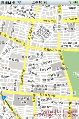
☉效果畫面:

☉步驟說明:
(1)建立一個新的Window-Based專案,將專案命名為LearnLoadMap
實際上我是繼續使用在iPhone開發心得03中所建立的專案。
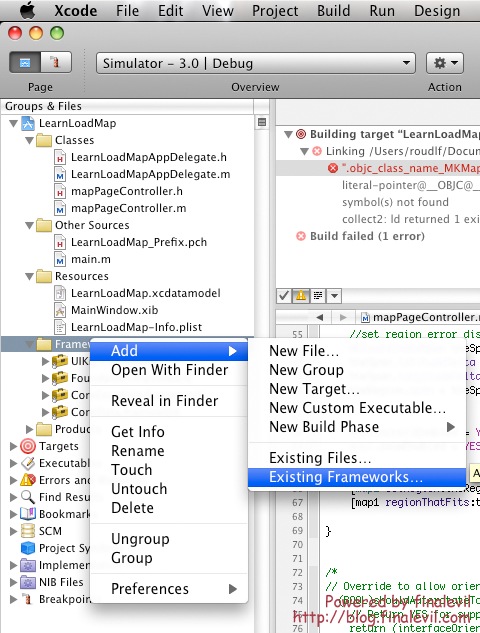
(2)加入Mapkit Framework
在左方專案目錄的Framework資料夾上點選右鍵 Add->Existing Frameworks,選擇Mapkit.Framework

(3)接著我在專案中加入了ViewController,並命名為mapPageController
不知道怎麼加入和使用Library中的View Controller可以參考
[iPhone程式]iPhone開發心得03-在Window中加入一個UIViewController
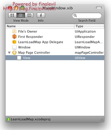
現在MainWindow.xib的內容應該長的像這樣:

(4)在mapPageController.h中import mapkit.h,mapkit.h包含了所有關於map會使用到的類別,並且宣告一個MKMapView,我們會在mapPageController.m中使用到。最重要的一點是宣告<mkmapviewdelegate>,表示mapPageController可以指定成MKMapView的委派。
(5)在mapPageController.m
用synthesize指示詞設定map1變數為public
在viewDidLoad方法中撰寫載入地圖。
當地圖由中心往外延伸的距離小,那麼螢幕上地圖要顯示的區域就會比較小塊,地圖看起來就會比較大。
當MKMapView準備完成後,我們要將它顯示在畫面上,因此最後一行可以看到我將map加入self.view中。
☉限制:必須將iPhone的作業系統更新到OS 3.0版本,開發使用的SDK也要是SDK3.0才有內建Mapkit Framework。
☉效果畫面:

☉步驟說明:
(1)建立一個新的Window-Based專案,將專案命名為LearnLoadMap
實際上我是繼續使用在iPhone開發心得03中所建立的專案。
(2)加入Mapkit Framework
在左方專案目錄的Framework資料夾上點選右鍵 Add->Existing Frameworks,選擇Mapkit.Framework

(3)接著我在專案中加入了ViewController,並命名為mapPageController
不知道怎麼加入和使用Library中的View Controller可以參考
[iPhone程式]iPhone開發心得03-在Window中加入一個UIViewController
現在MainWindow.xib的內容應該長的像這樣:

(4)在mapPageController.h中import mapkit.h,mapkit.h包含了所有關於map會使用到的類別,並且宣告一個MKMapView,我們會在mapPageController.m中使用到。最重要的一點是宣告<mkmapviewdelegate>,表示mapPageController可以指定成MKMapView的委派。
#import <uikit uikit.h>#import <mapkit/mapkit.h>@interface mapPageController : UIViewController <mkmapviewdelegate> {MKMapView *map1;}@property (nonatomic,retain) IBOutlet MKMapView *map1;@end(5)在mapPageController.m
用synthesize指示詞設定map1變數為public
@synthesize map1;
在viewDidLoad方法中撰寫載入地圖。
- (void)viewDidLoad { [super viewDidLoad];// Override point for customization after app launch CGRect rect = CGRectMake(0, 0, 320, 460);map1 = [[MKMapView alloc] initWithFrame:rect];[map1 setDelegate: self];[map1 setMapType: MKMapTypeStandard];MKCoordinateRegion theRegion;//set region centerCLLocationCoordinate2D theCenter;theCenter.latitude =25.032054;theCenter.longitude = 121.529266;theRegion.center=theCenter;//set zoom levelMKCoordinateSpan theSpan;theSpan.latitudeDelta = 0.009;theSpan.longitudeDelta = 0.009;theRegion.span = theSpan;//set scroll and zoom actionmap1.scrollEnabled = YES; map1.zoomEnabled = YES; //set map Region[map1 setRegion:theRegion];[map1 regionThatFits:theRegion];[self.view addSubview:map1];}MKCoordinateRegion表示座標區域(地圖上的某個區域),其中包含兩個重要的屬性,Center和Span。Center表示這塊區域的中心位置。Span表示這塊區域由中心往外延伸的距離(也就是Zoon Level)。當地圖由中心往外延伸的距離小,那麼螢幕上地圖要顯示的區域就會比較小塊,地圖看起來就會比較大。
當MKMapView準備完成後,我們要將它顯示在畫面上,因此最後一行可以看到我將map加入self.view中。
- [iPhone程式]iPhone開發心得04-Mapkit之使用MKMapView實作Google Map
- [iPhone程式]iPhone開發心得05-Mapkit之在地圖上加入座標點,使用MKAnnotation和MKAnnotationView
- [iPhone程式]iPhone開發心得02-用UIApplication開啓內建軟體
- [iPhone程式]iPhone開發心得01-建立View和Controller的對應關係
- [iPhone程式]iPhone開發心得03-在Window中加入一個UIViewController
- iphone--MKMapView
- iphone MKMapView
- iphone 如何使用地图MapKit
- iphone 如何使用地图MapKit
- iphone 如何使用地图MapKit
- iphone 掉用google map
- MapKit之MKMapView的基本认识和使用(Swift)
- iphone 地图应用。MKMapView
- ios菜鸟之路:iphone google map 定位的实现
- iPhone 程式設計入門(3)iPhone 及 MacBook 使用兩週總結
- iphone ios行動應用程式開發:iOS平台特性整理
- iOS<MapKit/MapKit.h> MKMapView的简单使用
- iPhone Mapkit 之在地图加入坐标点
- pgbench的使用简介
- [iPhone程式]iPhone開發心得05-Mapkit之在地圖上加入座標點,使用MKAnnotation和MKAnnotationView
- 工作十年的程序员给年轻人的忠告
- [iPhone程式]如何取得使用者目前的座標位置
- 用jquery实现可以左右选择的菜单效果
- [iPhone程式]iPhone開發心得04-Mapkit之使用MKMapView實作Google Map
- Net验证码的实现
- 控件、成员变量、函数名建议的命名方式
- WP7 异步操作 HttpWebRequest
- Oracle主键自动增长
- [iPhone程式]iPhone開發心得03-在Window中加入一個UIViewController
- Android:LinearLayout布局和其嵌套运用举例
- CTabCtrl的使用
- 短地址转换原理


