android定位和地图开发实例
来源:互联网 发布:电脑刺绣软件 编辑:程序博客网 时间:2024/06/07 05:06
转至:http://blog.csdn.net/wangkuifeng0118/article/details/7244364
在android开发中地图和定位是很多软件不可或缺的内容,这些特色功能也给人们带来了很多方便。
首先介绍一下地图包中的主要类:
MapController : 主要控制地图移动,伸缩,以某个GPS坐标为中心,控制MapView中的view组件,管理Overlay,提供View的基本功能。使用多种地图模式(地图模式(某些城市可实时对交通状况进行更新),卫星模式,街景模式)来查看Google Map。常用方法:animateTo(GeoPoint point) setCenter(GeoPoint point) setZoom(int zoomLevel) 等。
Mapview : 是用来显示地图的view, 它派生自android.view.ViewGroup。当MapView获得焦点,可以控制地图的移动和缩放。地图可以以不同的形式来显示出来,如街景模式,卫星模式等,通过setSatellite(boolean) setTraffic(boolean), setStreetView(boolean) 方法。
Overlay : 是覆盖到MapView的最上层,可以扩展其ondraw接口,自定义在MapView中显示一些自己的东西。MapView通过MapView.getOverlays()对Overlay进行管理。
Projection :MapView中GPS坐标与设备坐标的转换(GeoPoint和Point)。
定位系统包中的主要类:
LocationManager:本类提供访问定位服务的功能,也提供获取最佳定位提供者的功能。另外,临近警报功能也可以借助该类来实现。
LocationProvider:该类是定位提供者的抽象类。定位提供者具备周期性报告设备地理位置的功能。
LocationListener:提供定位信息发生改变时的回调功能。必须事先在定位管理器中注册监听器对象。
Criteria:该类使得应用能够通过在LocationProvider中设置的属性来选择合适的定位提供者。
Geocoder:用于处理地理编码和反向地理编码的类。地理编码是指将地址或其他描述转变为经度和纬度,反向地理编码则是将经度和纬度转变为地址或描述语言,其中包含了两个构造函数,需要传入经度和纬度的坐标。getFromLocation方法可以得到一组关于地址的数组。
下面开始地图定位实例的开发,在开发地图前需要 获取Android地图 API密钥 网上有很多资料,这里就不再复述。
首先要在manifest.xml中设置全相应的权限和maps库:
- <application
- android:icon="@drawable/ic_launcher"
- android:label="@string/app_name" >
- <activity
- android:label="@string/app_name"
- android:name=".MyMapActivity" >
- <intent-filter >
- <action android:name="android.intent.action.MAIN" />
- <category android:name="android.intent.category.LAUNCHER" />
- </intent-filter>
- </activity>
- <SPAN style="COLOR: #ff6666">
- <uses-library android:name="com.google.android.maps" /></SPAN>
- </application>
- <SPAN style="COLOR: #ff6666"> <uses-permission android:name="android.permission.INTERNET" />
- <uses-permission android:name="android.permission.ACCESS_FINE_LOCATION" />
- <uses-permission android:name="android.permission.ACCESS_COARSE_LOCATION" /></SPAN>
<application android:icon="@drawable/ic_launcher" android:label="@string/app_name" > <activity android:label="@string/app_name" android:name=".MyMapActivity" > <intent-filter > <action android:name="android.intent.action.MAIN" /> <category android:name="android.intent.category.LAUNCHER" /> </intent-filter> </activity><span style="color:#ff6666;"> <uses-library android:name="com.google.android.maps" /></span> </application> <span style="color:#ff6666;"> <uses-permission android:name="android.permission.INTERNET" /> <uses-permission android:name="android.permission.ACCESS_FINE_LOCATION" /> <uses-permission android:name="android.permission.ACCESS_COARSE_LOCATION" /></span>在上面我标红的千万不要忘记。
layout下的main.xml:
- <?xml version="1.0" encoding="utf-8"?>
- <LinearLayout xmlns:android="http://schemas.android.com/apk/res/android"
- android:layout_width="fill_parent"
- android:layout_height="fill_parent"
- android:orientation="vertical" >
- <com.google.android.maps.MapView
- android:id="@+id/mapview"
- android:layout_width="fill_parent"
- android:layout_height="fill_parent"
- android:apiKey="008uu0x2a7GWlK2LzCW872afBAPLhJ-U2R26Wgw"
- />
- </LinearLayout>
<?xml version="1.0" encoding="utf-8"?><LinearLayout xmlns:android="http://schemas.android.com/apk/res/android" android:layout_width="fill_parent" android:layout_height="fill_parent" android:orientation="vertical" > <com.google.android.maps.MapView android:id="@+id/mapview" android:layout_width="fill_parent" android:layout_height="fill_parent" android:apiKey="008uu0x2a7GWlK2LzCW872afBAPLhJ-U2R26Wgw" /></LinearLayout>
下面是核心代码,重要的地方我做了注释:
- public class MyMapActivity extends MapActivity {
- /** Called when the activity is first created. */
- private MapController mapController;
- private MapView mapView;
- private MyOverLay myOverLay;
- @Override
- public void onCreate(Bundle savedInstanceState) {
- super.onCreate(savedInstanceState);
- setContentView(R.layout.main);
- LocationManager locationManager=(LocationManager) getSystemService(Context.LOCATION_SERVICE);
- mapView=(MapView) this.findViewById(R.id.mapview);
- //设置交通模式
- mapView.setTraffic(true);
- //设置卫星模式
- mapView.setSatellite(false);
- //设置街景模式
- mapView.setStreetView(false);
- //设置缩放控制
- mapView.setBuiltInZoomControls(true);
- mapView.setClickable(true);
- mapView.setEnabled(true);
- //得到MapController实例
- mapController=mapView.getController();
- mapController.setZoom(15);
- myOverLay=new MyOverLay();
- List<Overlay> overLays=mapView.getOverlays();
- overLays.add(myOverLay);
- Criteria criteria=new Criteria();
- criteria.setAccuracy(Criteria.ACCURACY_FINE);
- criteria.setAltitudeRequired(false);
- criteria.setBearingRequired(false);
- criteria.setCostAllowed(false);
- criteria.setPowerRequirement(Criteria.POWER_LOW);
- //取得效果最好的Criteria
- String provider=locationManager.getBestProvider(criteria, true);
- //得到Location
- Location location=locationManager.getLastKnownLocation(provider);
- updateWithLocation(location);
- //注册一个周期性的更新,3秒一次
- locationManager.requestLocationUpdates(provider, 3000, 0, locationListener);
- }
- @Override
- public boolean onCreateOptionsMenu(Menu menu) {
- // TODO Auto-generated method stub
- menu.add(0, 1, 1, "交通模式");
- menu.add(0,2,2,"卫星模式");
- menu.add(0,3,3,"街景模式");
- return super.onCreateOptionsMenu(menu);
- }
- @Override
- public boolean onOptionsItemSelected(MenuItem item) {
- // TODO Auto-generated method stub
- super.onOptionsItemSelected(item);
- switch (item.getItemId()) {
- case 1://交通模式
- mapView.setTraffic(true);
- mapView.setSatellite(false);
- mapView.setStreetView(false);
- break;
- case 2://卫星模式
- mapView.setSatellite(true);
- mapView.setStreetView(false);
- mapView.setTraffic(false);
- break;
- case 3://街景模式
- mapView.setStreetView(true);
- mapView.setTraffic(false);
- mapView.setSatellite(false);
- break;
- default:
- mapView.setTraffic(true);
- mapView.setSatellite(false);
- mapView.setStreetView(false);
- break;
- }
- return true;
- }
- private void updateWithLocation(Location location){
- if(location!=null){
- //为绘制类设置坐标
- myOverLay.setLocation(location);
- GeoPoint geoPoint=new GeoPoint((int)(location.getLatitude()*1E6), (int)(location.getLongitude()*1E6));
- //定位到指定的坐标
- mapController.animateTo(geoPoint);
- mapController.setZoom(15);
- }
- }
- private final LocationListener locationListener=new LocationListener() {
- @Override
- public void onStatusChanged(String provider, int status, Bundle extras) {
- // TODO Auto-generated method stub
- }
- @Override
- public void onProviderEnabled(String provider) {
- // TODO Auto-generated method stub
- }
- @Override
- public void onProviderDisabled(String provider) {
- // TODO Auto-generated method stub
- }
- //当坐标改变时出发此函数
- @Override
- public void onLocationChanged(Location location) {
- // TODO Auto-generated method stub
- updateWithLocation(location);
- }
- };
- class MyOverLay extends Overlay{
- private Location location;
- public void setLocation(Location location){
- this.location=location;
- }
- @Override
- public boolean draw(Canvas canvas, MapView mapView, boolean shadow,
- long when) {
- // TODO Auto-generated method stub
- super.draw(canvas, mapView, shadow);
- Paint paint=new Paint();
- Point myScreen=new Point();
- //将经纬度换成实际屏幕的坐标。
- GeoPoint geoPoint=new GeoPoint((int)(location.getLatitude()*1E6), (int)(location.getLongitude()*1E6));
- mapView.getProjection().toPixels(geoPoint, myScreen);
- paint.setStrokeWidth(1);
- paint.setARGB(255, 255, 0, 0);
- paint.setStyle(Paint.Style.STROKE);
- Bitmap bmp=BitmapFactory.decodeResource(getResources(), R.drawable.mypicture);
- //把这张图片画到相应的位置。
- canvas.drawBitmap(bmp, myScreen.x, myScreen.y,paint);
- canvas.drawText("天堂没有路", myScreen.x, myScreen.y, paint);
- return true;
- }
- }
- @Override
- protected boolean isRouteDisplayed() {
- // TODO Auto-generated method stub
- return false;
- }
- @Override
- public boolean onKeyDown(int keyCode, KeyEvent event) {
- // TODO Auto-generated method stub
- if (keyCode == KeyEvent.KEYCODE_BACK) {
- AlertDialog.Builder builder = new AlertDialog.Builder(this);
- builder.setMessage("你确定退出吗?")
- .setCancelable(false)
- .setPositiveButton("确定",
- new DialogInterface.OnClickListener() {
- public void onClick(DialogInterface dialog,
- int id) {
- MyMapActivity.this.finish();
- android.os.Process
- .killProcess(android.os.Process
- .myPid());
- android.os.Process.killProcess(android.os.Process.myTid());
- android.os.Process.killProcess(android.os.Process.myUid());
- }
- })
- .setNegativeButton("返回",
- new DialogInterface.OnClickListener() {
- public void onClick(DialogInterface dialog,
- int id) {
- dialog.cancel();
- }
- });
- AlertDialog alert = builder.create();
- alert.show();
- return true;
- }
- return super.onKeyDown(keyCode, event);
- }
- }
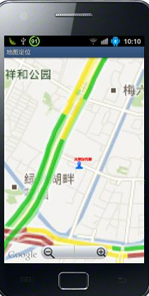
public class MyMapActivity extends MapActivity { /** Called when the activity is first created. */private MapController mapController;private MapView mapView;private MyOverLay myOverLay; @Override public void onCreate(Bundle savedInstanceState) { super.onCreate(savedInstanceState); setContentView(R.layout.main); LocationManager locationManager=(LocationManager) getSystemService(Context.LOCATION_SERVICE); mapView=(MapView) this.findViewById(R.id.mapview); //设置交通模式 mapView.setTraffic(true); //设置卫星模式 mapView.setSatellite(false); //设置街景模式 mapView.setStreetView(false); //设置缩放控制 mapView.setBuiltInZoomControls(true); mapView.setClickable(true); mapView.setEnabled(true); //得到MapController实例 mapController=mapView.getController(); mapController.setZoom(15); myOverLay=new MyOverLay(); List<Overlay> overLays=mapView.getOverlays(); overLays.add(myOverLay); Criteria criteria=new Criteria(); criteria.setAccuracy(Criteria.ACCURACY_FINE); criteria.setAltitudeRequired(false); criteria.setBearingRequired(false); criteria.setCostAllowed(false); criteria.setPowerRequirement(Criteria.POWER_LOW); //取得效果最好的Criteria String provider=locationManager.getBestProvider(criteria, true); //得到Location Location location=locationManager.getLastKnownLocation(provider); updateWithLocation(location); //注册一个周期性的更新,3秒一次 locationManager.requestLocationUpdates(provider, 3000, 0, locationListener); } @Override public boolean onCreateOptionsMenu(Menu menu) { // TODO Auto-generated method stub menu.add(0, 1, 1, "交通模式"); menu.add(0,2,2,"卫星模式"); menu.add(0,3,3,"街景模式"); return super.onCreateOptionsMenu(menu); } @Override public boolean onOptionsItemSelected(MenuItem item) { // TODO Auto-generated method stub super.onOptionsItemSelected(item); switch (item.getItemId()) {case 1://交通模式mapView.setTraffic(true);mapView.setSatellite(false);mapView.setStreetView(false);break;case 2://卫星模式mapView.setSatellite(true);mapView.setStreetView(false);mapView.setTraffic(false);break;case 3://街景模式mapView.setStreetView(true);mapView.setTraffic(false);mapView.setSatellite(false);break;default:mapView.setTraffic(true);mapView.setSatellite(false);mapView.setStreetView(false);break;} return true; } private void updateWithLocation(Location location){ if(location!=null){ //为绘制类设置坐标 myOverLay.setLocation(location); GeoPoint geoPoint=new GeoPoint((int)(location.getLatitude()*1E6), (int)(location.getLongitude()*1E6)); //定位到指定的坐标 mapController.animateTo(geoPoint); mapController.setZoom(15); } } private final LocationListener locationListener=new LocationListener() {@Overridepublic void onStatusChanged(String provider, int status, Bundle extras) {// TODO Auto-generated method stub}@Overridepublic void onProviderEnabled(String provider) {// TODO Auto-generated method stub}@Overridepublic void onProviderDisabled(String provider) {// TODO Auto-generated method stub}//当坐标改变时出发此函数@Overridepublic void onLocationChanged(Location location) {// TODO Auto-generated method stubupdateWithLocation(location);}}; class MyOverLay extends Overlay{ private Location location; public void setLocation(Location location){ this.location=location; } @Override public boolean draw(Canvas canvas, MapView mapView, boolean shadow, long when) { // TODO Auto-generated method stub super.draw(canvas, mapView, shadow); Paint paint=new Paint(); Point myScreen=new Point(); //将经纬度换成实际屏幕的坐标。 GeoPoint geoPoint=new GeoPoint((int)(location.getLatitude()*1E6), (int)(location.getLongitude()*1E6)); mapView.getProjection().toPixels(geoPoint, myScreen); paint.setStrokeWidth(1); paint.setARGB(255, 255, 0, 0); paint.setStyle(Paint.Style.STROKE); Bitmap bmp=BitmapFactory.decodeResource(getResources(), R.drawable.mypicture); //把这张图片画到相应的位置。 canvas.drawBitmap(bmp, myScreen.x, myScreen.y,paint); canvas.drawText("天堂没有路", myScreen.x, myScreen.y, paint); return true; } }@Overrideprotected boolean isRouteDisplayed() {// TODO Auto-generated method stubreturn false;}@Overridepublic boolean onKeyDown(int keyCode, KeyEvent event) {// TODO Auto-generated method stubif (keyCode == KeyEvent.KEYCODE_BACK) {AlertDialog.Builder builder = new AlertDialog.Builder(this);builder.setMessage("你确定退出吗?").setCancelable(false).setPositiveButton("确定",new DialogInterface.OnClickListener() {public void onClick(DialogInterface dialog,int id) {MyMapActivity.this.finish();android.os.Process.killProcess(android.os.Process.myPid()); android.os.Process.killProcess(android.os.Process.myTid()); android.os.Process.killProcess(android.os.Process.myUid());}}).setNegativeButton("返回",new DialogInterface.OnClickListener() {public void onClick(DialogInterface dialog,int id) {dialog.cancel();}});AlertDialog alert = builder.create();alert.show();return true;}return super.onKeyDown(keyCode, event);}}接下来看一下运行后效果:

可以放大缩小:
可是使用menu键,切换不同的模式:

上面是切换到了卫星模式。由于地图需要耗费大量的网络资源,如果网络比较慢的话会等待很长时间。
版权声明:本文为博主原创文章,未经博主允许不得转载。
- android定位和地图开发实例
- android定位和地图开发实例
- android定位和地图开发实例
- android定位和地图开发实例
- android定位和地图开发实例
- android定位和地图开发实例
- android定位和地图开发实例
- android定位和地图开发实例
- android定位和地图开发实例
- android定位和地图开发实例
- android定位和地图开发实例
- android定位和地图开发实例
- android定位和地图开发实例
- android定位和地图开发实例
- android定位和地图开发实例
- android定位和地图开发实例
- android定位和地图开发实例
- Android定位和地图开发实例
- leetcode 134 —— Gas Station
- Polar Code主要研究者的个人主页(持续更新中........)
- HDU5379.Mahjong tree
- Construct Binary Tree from Inorder and Preorder(Inorder and Postorder) Traversal
- 【转】Web 开发调试工具 Livepool
- android定位和地图开发实例
- Git 查看修改历史
- 2015-8-13 省赛模拟总结
- scala-07Scala类的属性和对象私有字段实战详解
- vector用法
- hdu1312
- hdu 5374 Tetris(模拟俄罗斯方块)
- jQuery 获取当前节点的html包含当前节点的方法
- 面向对象,集合篇(1)