C# ArcEngine TOCControl上实现右键
来源:互联网 发布:判断平年和闰年 编程 编辑:程序博客网 时间:2024/05/20 17:07
C# ArcEngine TOCControl上实现右键
第一种方法:使用contextMenuStrip控件
1.新建一个窗体AttributeTable,并定义一个全局变量mLayer,让主窗体里面的axMapControl1的layer传进来,从而获取属性列表!
ILayer mLayer; public AttributeTable(ILayer layer) { InitializeComponent(); mLayer = layer; }
在AttributteTable窗体的load事件下加载属性表
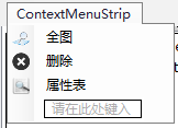
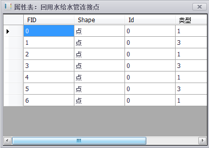
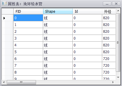
private void AttributeTable_Load(object sender, EventArgs e) { IFeatureLayer pFeatureLayer = mLayer as IFeatureLayer; IFeatureClass pFeatureClass = pFeatureLayer.FeatureClass; DataTable dt = new DataTable(); if (pFeatureClass != null) { DataColumn dc; for (int i = 0; i < pFeatureClass.Fields.FieldCount; i++) { dc = new DataColumn(pFeatureClass.Fields.get_Field(i).Name); dt.Columns.Add(dc);//获取所有列的属性值 } IFeatureCursor pFeatureCursor = pFeatureClass.Search(null, false); IFeature pFeature = pFeatureCursor.NextFeature(); DataRow dr; while (pFeature != null) { dr = dt.NewRow(); for (int j = 0; j < pFeatureClass.Fields.FieldCount; j++) { //判断feature的形状 if (pFeature.Fields.get_Field(j).Name == "Shape") { if (pFeature.Shape.GeometryType == ESRI.ArcGIS.Geometry.esriGeometryType.esriGeometryPoint) { dr[j] = "点"; } if (pFeature.Shape.GeometryType == ESRI.ArcGIS.Geometry.esriGeometryType.esriGeometryPolyline) { dr[j] = "线"; } if (pFeature.Shape.GeometryType == ESRI.ArcGIS.Geometry.esriGeometryType.esriGeometryPolygon) { dr[j] = "面"; } } else { dr[j] = pFeature.get_Value(j).ToString();//增加行 } } dt.Rows.Add(dr); pFeature = pFeatureCursor.NextFeature(); } dataGridView1.DataSource = dt; } }2.建立右键菜单(本例只是做了打开属性表操作),入下图:
在主窗口内定义一个公共变量:public ILayer layer;
在axTOCControl1_OnMouseDown事件下
private void axTOCControl1_OnMouseDown(object sender, ITOCControlEvents_OnMouseDownEvent e) { if (e.button == 2) { esriTOCControlItem item = esriTOCControlItem.esriTOCControlItemNone; IBasicMap map = new MapClass(); layer = new FeatureLayerClass(); object other = new object(); object index = new object(); axTOCControl1.HitTest(e.x, e.y, ref item, ref map, ref layer, ref other, ref index); //实现赋值,ref的参数必须初始化 if (item == esriTOCControlItem.esriTOCControlItemLayer) ////点击的是图层的话,就显示右键菜单 { contextMenuStrip1.Show(axTOCControl1, new System.Drawing.Point(e.x, e.y)); } } }3.单击contextMenuStrip1,显示属性表。
private void contextMenuStrip1_Click(object sender, EventArgs e) { AttributeTable attributeTable = new AttributeTable(layer); attributeTable.Text = "属性表:" + layer.Name; attributeTable.ShowDialog(); }效果如下:
第一种方法:使用Base Command 类
1.新建一个Base Command类OpenAttributeTable,并定义一个全局变量 private ILayer m_layer,代码如下:
private ILayer m_layer;public OpenAttributeTable(ILayer pLayer){ base.m_category = ""; base.m_caption = "打开属性表"; base.m_message = ""; base.m_toolTip = ""; base.m_name = ""; m_layer = pLayer; try {//加载附加图片 string bitmapResourceName = GetType().Name + ".bmp"; base.m_bitmap = new Bitmap(GetType(), bitmapResourceName); } catch (Exception ex) { System.Diagnostics.Trace.WriteLine(ex.Message, "Invalid Bitmap"); }}然后在其单击事件下面加载属性表,代码如下:
public override void OnClick() { // TODO: Add OpenAttributeTable.OnClick implementation IFeatureLayer pFeatureLayer = m_layer as IFeatureLayer; IFeatureClass pFeatureClass = pFeatureLayer.FeatureClass; DataTable dt = new DataTable(); if (pFeatureClass != null) { DataColumn dc; for (int i = 0; i < pFeatureClass.Fields.FieldCount; i++) { dc = new DataColumn(pFeatureClass.Fields.get_Field(i).Name); dt.Columns.Add(dc); } IFeatureCursor pFeatureCursor = pFeatureClass.Search(null, false); IFeature pFeature = pFeatureCursor.NextFeature(); DataRow dr; while (pFeature != null) { dr = dt.NewRow(); for (int j = 0; j < pFeatureClass.Fields.FieldCount; j++) { if (pFeature.Fields.get_Field(j).Name == "Shape") { if (pFeature.Shape.GeometryType == ESRI.ArcGIS.Geometry.esriGeometryType.esriGeometryPoint) { dr[j] = "点"; } if (pFeature.Shape.GeometryType == ESRI.ArcGIS.Geometry.esriGeometryType.esriGeometryPolyline) { dr[j] = "线"; } if (pFeature.Shape.GeometryType == ESRI.ArcGIS.Geometry.esriGeometryType.esriGeometryPolygon) { dr[j] = "面"; } } else { dr[j] = pFeature.get_Value(j).ToString(); } } dt.Rows.Add(dr); pFeature = pFeatureCursor.NextFeature(); } AttributeTable AT = new AttributeTable(); AT.Text = "属性表:" + pFeatureLayer.Name; AT.Show(); AT.dataGridView1.DataSource = dt; } }2. 在axTOCControl1_OnMouseDown事件下完成单击事件,代码如下:
private void axTOCControl1_OnMouseDown(object sender, ITOCControlEvents_OnMouseDownEvent e) { if (e.button == 2) { esriTOCControlItem item = esriTOCControlItem.esriTOCControlItemNone; IBasicMap map = new MapClass(); layer = new FeatureLayerClass(); object other = new object(); object index = new object(); axTOCControl1.HitTest(e.x, e.y, ref item, ref map, ref layer, ref other, ref index); if (item == esriTOCControlItem.esriTOCControlItemLayer) { m_ToolMenuLayer.AddItem(new Owntolayer(layer, axMapControl1, eve), 0, 0, false, ESRI.ArcGIS.SystemUI.esriCommandStyles.esriCommandStyleIconAndText); m_ToolMenuLayer.AddItem(new FullExtent(axMapControl1), 0, 1, false, ESRI.ArcGIS.SystemUI.esriCommandStyles.esriCommandStyleIconAndText); m_ToolMenuLayer.AddItem(new DeleteLayer(layer), 0, 2, false, ESRI.ArcGIS.SystemUI.esriCommandStyles.esriCommandStyleIconAndText); m_ToolMenuLayer.AddItem(new OpenAttributeTable(layer), 0, 3, false, ESRI.ArcGIS.SystemUI.esriCommandStyles.esriCommandStyleIconAndText); m_ToolMenuLayer.PopupMenu(e.x, e.y, m_TocControl.hWnd); m_ToolMenuLayer.RemoveAll(); } } }效果如下:
说明:
1.public int AddItem (object item,int SubType,int index,bool beginGroup,esriCommandStyles Style)
第一个参数:菜单项的内容,功能实现。
第二个参数:对于一个工具定义多个 type 的时候,才会用到,每一个 int 代表一个新的实现。
第三个参数:索引值,在菜单项上面显示的位置。默认为 -1,按书写顺序排序。
第四个参数:是否开始一个新组,就是在其上面有一个“——”的效果。
第五个参数:显示样式。
2. axTOCControl1.HitTest()方法
[C#]public void HitTest ( intX, intY, ref esriTOCControlItemItemType, ref IBasicMapBasicMap, ref ILayerLayer, ref objectUnk, ref objectData);Product Availability
Description
x is the X coordinate, in pixels, where the mouse button was pressed referenced against the origin (0, 0) of the TOCControl (the top left hand corner).
y is the Y coordinate, in pixels, where the mouse button was pressed referenced against the origin (0, 0) of the TOCControl (the top left hand corner).
ItemType specifies an enumeration indicating the type of item (none, map, layer, heading or legend class).
Map specifies an IMap object.
Layer specifies an ILayer object.
Unk specifies an ILegendGroup object.
Data specifies a long indicating the index of the legend class within the legend group. Use this index in conjunction with the legend group to obtain a particular legend class. An index of -1 refers to the heading if it is present.
注:本文所用的环境:windows7操作系统;VS2010;基于C#语言;ArcEngine版本为10.1。

山茶花
- C# ArcEngine TOCControl上实现右键
- C# ArcEngine TOCControl上实现右键
- TOCControl右键菜单功能实现
- TOCControl右键菜单
- TOCControl右键菜单
- ArcEngine开发——从TocControl上获取鼠标点击位置的信息(转载)
- TOCControl的常见右键操作
- ArcEngine 鹰眼功能C#实现
- TOCControl代码实现图层名可编辑
- Arcengine实现:在 MapControl 上绘制几何图形
- Arcengine+C#实现矢量数据的裁剪
- TextBox上实现右键菜单
- TextBox上实现右键菜单
- TextBox上实现右键菜单
- TextBox上实现右键菜单
- TextBox上实现右键菜单
- TextBox上实现右键菜单
- ArcEngine中使用上下左右键移动地图功能的实现
- 文章列表页
- 安卓上层代码通过onTouch事件模拟实现"onClick"的动作,以及触屏灵敏度的设置
- Tomcat内存设置详解
- linux通过bridge各个网口之后dhcpd分配IP很慢的原因
- 向文件中追加内容
- C# ArcEngine TOCControl上实现右键
- android app如何调用支付宝接口
- Java的数据类型
- x-code 快捷键
- RxJava_ReadMe
- 一个新手从零搭建服务器的笔记教程
- Microsoft Windows 2008 IIS 7.0 -PFX证书导入
- The superclass "javax.servlet.http.HttpServlet" was not found on the Java Build Path
- sql server数据库的备份和还原