POJ1328 Radar Installation(贪心)
来源:互联网 发布:wps的数据有效性在哪 编辑:程序博客网 时间:2024/06/05 19:57
Description
Assume the coasting is an infinite straight line. Land is in one side of coasting, sea in the other. Each small island is a point locating in the sea side. And any radar installation, locating on the coasting, can only cover d distance, so an island in the sea can be covered by a radius installation, if the distance between them is at most d.
We use Cartesian coordinate system, defining the coasting is the x-axis. The sea side is above x-axis, and the land side below. Given the position of each island in the sea, and given the distance of the coverage of the radar installation, your task is to write a program to find the minimal number of radar installations to cover all the islands. Note that the position of an island is represented by its x-y coordinates.
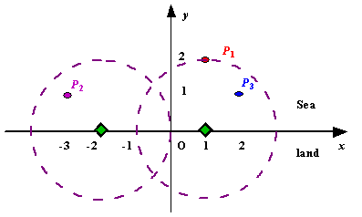
Figure A Sample Input of Radar Installations
We use Cartesian coordinate system, defining the coasting is the x-axis. The sea side is above x-axis, and the land side below. Given the position of each island in the sea, and given the distance of the coverage of the radar installation, your task is to write a program to find the minimal number of radar installations to cover all the islands. Note that the position of an island is represented by its x-y coordinates.
Figure A Sample Input of Radar Installations
Input
The input consists of several test cases. The first line of each case contains two integers n (1<=n<=1000) and d, where n is the number of islands in the sea and d is the distance of coverage of the radar installation. This is followed by n lines each containing two integers representing the coordinate of the position of each island. Then a blank line follows to separate the cases.
The input is terminated by a line containing pair of zeros
The input is terminated by a line containing pair of zeros
Output
For each test case output one line consisting of the test case number followed by the minimal number of radar installations needed. "-1" installation means no solution for that case.
Sample Input
3 21 2-3 12 11 20 20 0
Sample Output
Case 1: 2Case 2: 1
Source
Beijing 2002
题目链接:poj1328
首先这个题的题意就是在一个平面坐标内,有n个处于x轴上方的点,作为岛屿。在X轴上可以安放雷达,雷达的半径为d。题目要求根据n个岛屿的坐标和雷达的半径d求解出最少需要多少个雷达才嫩把所有的岛屿包括进来。如果没有办法把所有的包括进来,则出输出-1.
第一次看到这个题我的想法和后来在网上找的差不多,我想的是将每个坐标(x0,y0)与X轴的交点求出来,求法是勾股定理x=x0-根号下(d²-y0²),然后画出一个区间[xd,yd],比较这n个岛屿的区间之间是否存在重叠,若存在则安装一个雷达。
但是后来想了想可行度不高,于是看了下网上的解析,其实就是一个数据结构设置的不当的问题,网上是将每个点与X轴的左右交点存储在一个结构体数组中,然后排序,比较左右两岛屿的左右两个交点的左右关系。并用temp来标记稍微靠右边的那个点,用p[i]来更新新的点,直到temp.right<p[i].left为止,再让temp=p[i],进行新的比较。还是这种方法比较好实现。
下面是代码和一部分解析。(转载)

图中ABCD为海岛的位置。假设本题半径为2(符合坐标系),那么A点坐标为(1,1)以此类推。
在题中,记录每个点的坐标,并把一个点新加一个标记变量以标记是否被访问过。
首先以A为圆心,r为半径做圆,交x轴与E1(右)点,做出如图中绿色虚线圆。然后以E1为圆心,半径为r做圆。看此时下一点(B)是否在该圆中。如果在,那么将该点标记变量变为true,再判下一点(C),如果不在那么就新增一个雷达。
后来,换了思路,存储图中红色圆与X轴的交点。
还是原来的贪心思路,仍然先排序,但排序的准则是按红色圆与x轴左交点的先后顺序。
如图,如果B点圆(且如此称呼)的左交点(J1点)在A点圆右交点(E1)左侧,那么B点一定涵盖在A点圆内部。再如图,如果D点圆的左交点(图中未标示)在A点圆的右交点(未标示)右,则D点不在A点圆中。
故,有如下代码:
#include <iostream> #include <algorithm> #include <stdlib.h> #include <math.h> using namespace std; struct point { double left, right; }p[2010], temp; bool operator < (point a, point b) { return a.left < b.left; } int main() { int n; double r; int kase = 0; while (cin >> n >> r && (n || r)) { bool flag = false; for (int i = 0; i < n; i++) { double a, b; cin >> a >> b; if (fabs(b) > r) { flag = true; } else { p[i].left = a * 1.0 - sqrt(r * r - b * b); p[i].right = a * 1.0 + sqrt(r * r - b * b); } } cout << "Case " << ++kase << ": "; if (flag) { cout << -1 << endl; } else { int countt = 1; sort(p, p + n); temp = p[0]; for (int i = 1; i < n; i++) { if (p[i].left > temp.right) { countt++; temp = p[i]; } else if (p[i].right < temp.right) { temp = p[i]; } } cout << countt << endl; } } } 阅读全文
0 0
- poj1328 Radar Installation(贪心)
- POJ1328--Radar Installation(贪心)
- poj1328 Radar Installation(贪心)
- poj1328 Radar Installation(贪心)
- POJ1328-Radar Installation(贪心)
- POJ1328 Radar Installation(贪心)
- #POJ1328#Radar Installation(贪心)
- POJ1328 Radar Installation(贪心)
- Radar Installation(POJ1328, 贪心)
- POJ1328 Radar Installation 贪心
- POJ1328 Radar Installation 贪心
- 【贪心】POJ1328 Radar Installation
- poj1328 Radar Installation 贪心
- 【POJ1328】Radar Installation 贪心
- POJ1328 Radar Installation 贪心
- 贪心- poj1328 Radar Installation
- POJ1328 Radar Installation 贪心
- poj1328 Radar Installation 贪心
- linux基础指令
- A
- Android-20及以上无法使用EditText控件
- VS2013动态库文件的创建及其使用详解
- Web报表系统葡萄城报表:报表打印
- POJ1328 Radar Installation(贪心)
- spring详解事务传播属性和隔离级别
- 优化网站性能必备的6种架构方案
- idea 中getServletContext() 报红
- 主席树
- HihoCoder
- Tinker 常见问题
- @RequestBody 请求实体注解
- A